

Merapi Volcanic Eruptions:Indonesia
Volcano Learning Zone > Volcanic eruption Casestudies >Merapi
 Where is the volcano?
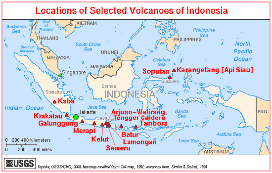
Merapi volcano is part of the Pacific Ring of Fire on the border of Central Java and Indonesia. It is 28 km north of Yogyakarta city (population 1.5 million) but the slopes are populated too .The volcano is 1968m (9738 ft) tall . Some villages are located as high as 1700m.
Why is there a volcano here?
Merapi is one of 129 volcanoes in Indonesia situated above a subduction zone where the Indo-Australian plate is sinking beneath the Eurasian Plate. The volcano is around 400 000 years old.
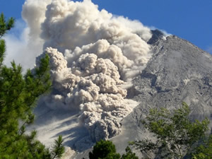
Eruption Style
Merapi is a stratovolcano built up of layers of ash and lava. Initially 400 000 years ago the volcano mainly erupted basaltic lavas and erupted effusively. In the last 10 000 years the volcano has become more explosive and has generated pyroclastic flows from andesitic lava domes. Pyroclastic flows have also been generated from eruption column collapse.
Recent Eruptions 2006
In April 2006 seismic activity indicated that new magma was rising within the volcano and that eruptions were very likely. Through the rest of April villages were prepared for evacuation and ash clouds were rising up to 4000m. During May lava flows appeared and on the 11th May and 17000 people were evacuated.Some people decided to stay to look after their crops and animals. On mAy 27 th a large earthuake to the south killed 5000 and displaced 200 000, During June lava and pyroclastic flows caused 11 000 people to be evacuated to escape the pyroclastic flows.
Hazard Management 2006
The evacuations were relativley successful as only 2 people were killed as a direct result of the eruption. Merapi is a closely monitored volcano and currently has 8 seismometers from which the location of earthquaes can be found. a zone of no earthquakes 1.5km below the summit has been deduced as the magma chamber.Tiltmetres measure the inflation and deflation of the volcano.
2010 Eruption
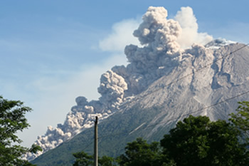 Increased seismic activity in September heralded the beginning of a new eruptive phase. White plumes were seen rising above the crater and the lava dome began to inflate.Frequent earthquakes continued and lava began to flow in late October. People were evacuated from a 10km exclusion zone, this affected 19000 people but is unclear how many complied. The magma rose to 1000m below the summit. 153 people had died by November 10th and 320 000 people had left their homes. By 24 November 324 people had lost their lives mostly from burns sustained in pyroclastic flows .The longest flows reached 9 miles from the summit.By Dec 3rd deaths had reached 353 but the alert level was lowered but still with the risk of eruption clouds.
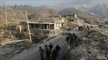
Lahars flowing down the Code river into the centre of Yogyacarta were asignificant threat.Some areas of the city suffered from lahars .
280,000 who normally live on the fertile slopes of the volcano took refuge in 700 emergency shelters. There reports of poor sanitation, and not enough toilets or clean drinking water. More than 2,000 homes were destroyed, 350,000 people evacuated,airports closed and hundreds of international flights cancelled to and from Indonesia. Financial losses are estimated at US$781 million.
Hazard Management
 Volcanic Hazards in Indonesia are managed by the National Disaster Mitigation Agency(BNPB)in conjunction with the Centre for Volcanology and Geological Hazard Mitigation (PVMBG). They are responsible for monitoring, issuing alert levels and evacuation orders. In remote and rural areas with srong cultural links to the volcano it can be impossible to ensure that all are evacuated . This reflected in the death tolls from pyroclastic flows.However an estimated 20 000lives were saved by the successful evacuations.
Why not look at our World volcanoes section or Volcanic Hazards page.